![](/images/other/stat-length.png)
![Excursión Otra actividad Reichenbach im Kandertal - Gornern - Sefinenfurgge - Poganggen - Mürren - Photo](https://media.geolcdn.com/t/1900/400/ext.pjpeg?maxdim=2&url=https%3A%2F%2Fstatic1.geolcdn.com%2Fsiteimages%2Fupload%2Ffiles%2F1545311037marcheuse_200dpi.jpg)
Gornern - Sefinenfurgge - Poganggen - Mürren
bayardpaul
Usuario
![Longitud](/images/other/stat-length.png)
Longitud
14,8 km
![Altitud máxima](https://static1.geolcdn.com/siteimages/upload/files/1508320355ic_sort_altitude_max_24dp.png)
Altitud máxima
2605 m
![Desnivel positivo](https://static1.geolcdn.com/siteimages/upload/files/1508320355ic_sort_den_pos_24dp.png)
Desnivel positivo
1281 m
![Km-Effort](/images/other/stat-length.png)
Km-Effort
31 km
![Altitud mínima](https://static1.geolcdn.com/siteimages/upload/files/1508320355ic_sort_altitude_min_24dp.png)
Altitud mínima
1457 m
![Desnivel negativo](https://static1.geolcdn.com/siteimages/upload/files/1508320355ic_sort_den_neg_24dp.png)
Desnivel negativo
1096 m
![Boucle](https://static1.geolcdn.com/siteimages/upload/files/16400158638029165_repeat_loop_refresh_sync_direction_icon.png)
Boucle
No
Fecha de creación :
2014-12-11 00:00:00.0
Última modificación :
2014-12-11 00:00:00.0
![Otra actividad](https://static1.geolcdn.com/sitytour/trail-icons/900.png)
--
Dificultad : Desconocido
![Escanee este código QR para abrir la excursión en la aplicación SityTrail](https://capi.geolives.com/qq0zvz2zws4bq2lad0pu/sitytour/trails/19789/qr.png?size=200)
Aplicación GPS de excursión GRATIS
A propósito
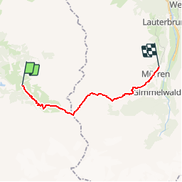
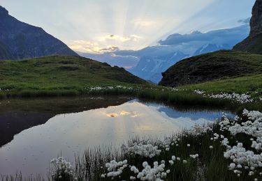
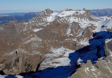
Ruta Otra actividad de 14,8 km a descubrir en Berna, Verwaltungskreis Frutigen-Niedersimmental, Reichenbach im Kandertal. Esta ruta ha sido propuesta por bayardpaul.
Descripción
Leubin-Huber Hansrudolf
Bahnhofstrasse 51
4132 Muttenz
061 461 43 28
Localización
País:
Switzerland
Región :
Berna
Departamento/provincia :
Verwaltungskreis Frutigen-Niedersimmental
Municipio :
Reichenbach im Kandertal
Localidad:
Unknown
Salida:(Dec)
Salida:(UTM)
405263 ; 5156096 (32T) N.
Comentarios
Excursiones cerca
![Excursión A pie Lauterbrunnen - CH-Rote Härd-Sefinenfurgge - Photo](https://media.geolcdn.com/t/375/260/acb83571-17f7-45d2-825e-b2d0352cd8da.jpeg&format=jpg&maxdim=2)
![A pie A pie](https://static1.geolcdn.com/sitytour/trail-icons/100.png)
CH-Rote Härd-Sefinenfurgge
A pie
Fácil
Lauterbrunnen,
Berna,
Verwaltungskreis Interlaken-Oberhasli,
Switzerland
![](/images/other/stat-length.png)
4,1 km | 9 km-effort
2h 2min
![](https://static1.geolcdn.com/siteimages/upload/files/16400158638029165_repeat_loop_refresh_sync_direction_icon.png)
No
![Excursión A pie Lauterbrunnen - Sattel - Glütschnessli - Photo](https://media.geolcdn.com/t/375/260/5a3fcfc2-bf24-445e-abb4-4eb6a5887c5e.jpeg&format=jpg&maxdim=2)
![A pie A pie](https://static1.geolcdn.com/sitytour/trail-icons/100.png)
Sattel - Glütschnessli
A pie
Fácil
Lauterbrunnen,
Berna,
Verwaltungskreis Interlaken-Oberhasli,
Switzerland
![](/images/other/stat-length.png)
3,8 km | 7,2 km-effort
1h 37min
![](https://static1.geolcdn.com/siteimages/upload/files/16400158638029165_repeat_loop_refresh_sync_direction_icon.png)
No
![Excursión A pie Reichenbach im Kandertal - Gruenerli - Spiggergrund - Photo](https://media.geolcdn.com/t/375/260/ext.jpg?maxdim=2&url=https%3A%2F%2Fstatic1.geolcdn.com%2Fsiteimages%2Fupload%2Ffiles%2F1545311037marcheuse_200dpi.jpg)
![A pie A pie](https://static1.geolcdn.com/sitytour/trail-icons/100.png)
Gruenerli - Spiggergrund
A pie
Fácil
Reichenbach im Kandertal,
Berna,
Verwaltungskreis Frutigen-Niedersimmental,
Switzerland
![](/images/other/stat-length.png)
3,8 km | 5,6 km-effort
1h 16min
![](https://static1.geolcdn.com/siteimages/upload/files/16400158638029165_repeat_loop_refresh_sync_direction_icon.png)
No
![Excursión Otra actividad Reichenbach im Kandertal - ViaRegio_Jungfrau_6 - Photo](https://media.geolcdn.com/t/375/260/ext.jpg?maxdim=2&url=https%3A%2F%2Fstatic1.geolcdn.com%2Fsiteimages%2Fupload%2Ffiles%2F1545311037marcheuse_200dpi.jpg)
![Otra actividad Otra actividad](https://static1.geolcdn.com/sitytour/trail-icons/900.png)
ViaRegio_Jungfrau_6
Otra actividad
Muy fácil
Reichenbach im Kandertal,
Berna,
Verwaltungskreis Frutigen-Niedersimmental,
Switzerland
![](/images/other/stat-length.png)
21 km | 45 km-effort
9h 24min
![](https://static1.geolcdn.com/siteimages/upload/files/16400158638029165_repeat_loop_refresh_sync_direction_icon.png)
No
![Excursión Senderismo Reichenbach im Kandertal - Kiental Lehrpfad Griesalp - Photo](https://media.geolcdn.com/t/375/260/ext.jpg?maxdim=2&url=https%3A%2F%2Fstatic1.geolcdn.com%2Fsiteimages%2Fupload%2Ffiles%2F1553511878bg_sport_marche.png)
![Senderismo Senderismo](https://static1.geolcdn.com/sitytour/trail-icons/101.png)
Kiental Lehrpfad Griesalp
Senderismo
Muy fácil
Reichenbach im Kandertal,
Berna,
Verwaltungskreis Frutigen-Niedersimmental,
Switzerland
![](/images/other/stat-length.png)
8,3 km | 15,1 km-effort
Desconocido
![](https://static1.geolcdn.com/siteimages/upload/files/16400158638029165_repeat_loop_refresh_sync_direction_icon.png)
Sí
![Excursión Senderismo Reichenbach im Kandertal - Kiental: Lötschberg-Route ohne Gepäck - Photo](https://media.geolcdn.com/t/375/260/ext.jpg?maxdim=2&url=https%3A%2F%2Fstatic1.geolcdn.com%2Fsiteimages%2Fupload%2Ffiles%2F1553511878bg_sport_marche.png)
![Senderismo Senderismo](https://static1.geolcdn.com/sitytour/trail-icons/101.png)
Kiental: Lötschberg-Route ohne Gepäck
Senderismo
Muy fácil
Reichenbach im Kandertal,
Berna,
Verwaltungskreis Frutigen-Niedersimmental,
Switzerland
![](/images/other/stat-length.png)
14,1 km | 22 km-effort
Desconocido
![](https://static1.geolcdn.com/siteimages/upload/files/16400158638029165_repeat_loop_refresh_sync_direction_icon.png)
No
![Excursión Otra actividad Reichenbach im Kandertal - BLS Nordrampe - Photo](https://media.geolcdn.com/t/375/260/ext.jpg?maxdim=2&url=https%3A%2F%2Fstatic1.geolcdn.com%2Fsiteimages%2Fupload%2Ffiles%2F1545311037marcheuse_200dpi.jpg)
![Otra actividad Otra actividad](https://static1.geolcdn.com/sitytour/trail-icons/900.png)
BLS Nordrampe
Otra actividad
Muy fácil
Reichenbach im Kandertal,
Berna,
Verwaltungskreis Frutigen-Niedersimmental,
Switzerland
![](/images/other/stat-length.png)
16,6 km | 26 km-effort
Desconocido
![](https://static1.geolcdn.com/siteimages/upload/files/16400158638029165_repeat_loop_refresh_sync_direction_icon.png)
No
![Excursión Otra actividad Reichenbach im Kandertal - Kienttal-Chilfluepass - Photo](https://media.geolcdn.com/t/375/260/ext.jpg?maxdim=2&url=https%3A%2F%2Fstatic1.geolcdn.com%2Fsiteimages%2Fupload%2Ffiles%2F1545311037marcheuse_200dpi.jpg)
![Otra actividad Otra actividad](https://static1.geolcdn.com/sitytour/trail-icons/900.png)
Kienttal-Chilfluepass
Otra actividad
Muy fácil
Reichenbach im Kandertal,
Berna,
Verwaltungskreis Frutigen-Niedersimmental,
Switzerland
![](/images/other/stat-length.png)
11,2 km | 27 km-effort
Desconocido
![](https://static1.geolcdn.com/siteimages/upload/files/16400158638029165_repeat_loop_refresh_sync_direction_icon.png)
No